| Warner and Swasey Observatory |
| Case Western Reserve University | Nassau Station |
| Visitors |
|
» Home » News » Gallery » Reference » Weather |
| Science Resources |
|
» NSRT User Interface » Software » Data Archive » Download Data |

|
 |
How Points in the Sky Are Determined
 Celestial Sphere: The celestial sphere is an imaginary shell of infinite radius, centered on the observer. This concept is useful for determining positions in the sky.
Zenith: This is the point in the sky directly above the observer.
Celestial Poles: As the Earth rotates, the sky appears to rotate around two points in the sky, one aligned with the geographic North Pole, and the other aligned with the geographic South Pole. These two points are the north celestial pole and the south celestial pole . The north celestial pole can be seen in the Northern Hemisphere, and currently is very close to the star Polaris.
Celestial Equator: This is a great circle on the celestial sphere that is in the same plane as the Earth's equator. It is 90 degrees from each celestial pole, so it is directly halfway in between them. To a person standing on the Earth's equator, the celestial equator would appear to pass through their zenith.
Celestial Meridian: This is a great circle passing through the celestial poles and the observer's zenith.
Ecliptic: The path of the sun in the sky.
Vernal Equinox: This is one of the two points on the celestial sphere where the celestial equator and the ecliptic intersect. The vernal equinox marks the first day of spring. The autumnal equinox is the other point, and it marks the first day of autumn.
Summer Solstice: This is the northernmost excursion of the Sun along the ecliptic. The summer solstice is the longest day of the year. The southernmost excursion is the winter solstice.
Hour Circle: A great circle on the celestial sphere running north and south through the celestial poles.
Hour Angle: This is measured westward along the celestial equator from the local celestial meridian to an object's hour circle. 15 degrees in arc units equals 1 hour in time units, because it takes an object one hour to apparently move 15 degrees across the sky.
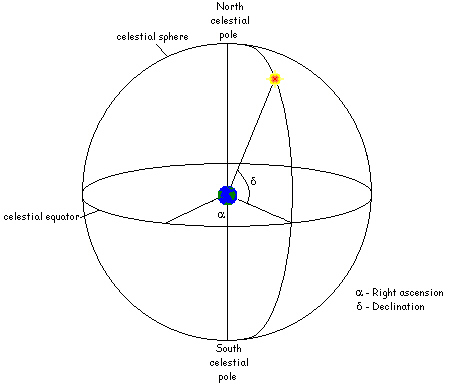 Equator System: This is a coordinate system attached to the celestial sphere itself, using right ascension and declination to notate the positions of celestial objects.
Right Ascension: The arc distance measured eastward along the celestial equator from the vernal equinox to the hour circle of the star; comparable to longitude.
Declination: The arc distance from celestial equator either north or south to the star, along the hour circle given by right ascension; comparable to latitude.
Epoch: This is the time frame for which the object's coordinates are valid. The star's apparent coordinates change with time, because of precession and proper motion, so it is necessary to know the time for which the given coordinates are precise.
Sidereal Day: This is the time required for the Earth to make a complete rotation with respect to the vernal equinox. This is slightly shorter than a solar day, which is the period of the Earth's rotation with respect to the Sun. The local day begins (00h 00m 00s) when the vernal equinox is on the celestial meridian. The sidereal day is 23 hours, 56 minutes, and 4.1 seconds long.
Sidereal Time: Official sidereal time is the day beginning at the hour angle of the vernal equinox. Star positions are given using this sidereal time. The position of a star with respect to the oberver's meridian is then related to the sidereal time.
Ephemeris Time: A time system based on dynamics, and which, unlike the other time systems, has an invariable rate. The beginning of ephemeris time (0 days, 12 hours) was near the beginning of 1900 when the Sun's longitude was 279 degrees 41 minutes 48.04 seconds. The ephemeris second, ephemeris day, etc. are defined at having specific, unchanging lengths.
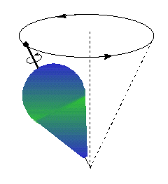
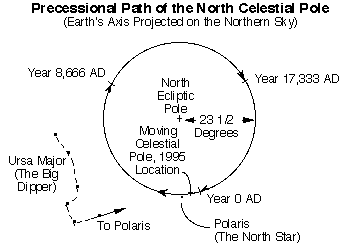
Precession: The Earth's motion is like a top, so the celestial equator and the vernal equinox slowly move with respect to the stars. The positions of the stars around the north celestial pole are also affected by this. The north celestial pole is currently very near Polaris, and it will take 26,000 years for the Earth to swing all the way around again. In 12,000 years, the north celestial pole will be fairly close to Vega.
Nutation: The precession is not completely smooth; the Earth wobbles as it precesses due to the gravitational pull of the Sun and the Moon on the Earth's equatorial bulge. Therefore, as it moves through the precessional circle, it moves in little waves with amplitude of 19 arc seconds and a period of 19 years.
Proper Motion: This is the rate at which directions in the sky change, in arc seconds per year. This is usually not observable in a year, but can be found by comparing the positions of stars in images taken about 10 years apart. Most of the stars are distant and so do not appear to move, but some nearby stars are observed to have changed position in relation to the others.
Created by Rebecca Stanek, December 1998
Illustrated by Marta Lewandowska, June 1999
©1997, 1998, 1999 CWRU Astronomy Dept.
comments
Last modified June 1999
Case Western Reserve University